Aboriginal Native American Mica Mining
in Western North Carolina
 |
"2012" Last Updated: June 11th, 2013 |
/ Home / Painting / 2012 / 2013 / Back Story and Research
Jeremiah's First Visit- June 2012
Jeremiah made his first visit in 2012 in late June. He and his wife Catanya and small son Elijah stayed with Diana and me at the cabin.
The initial objective of the visit was to determine whether the story about the discovery of a chamber at on the Sink Hole Mine in the 1950s had merit. So, I arranged a meeting with the "teenaged boy" who I learned was now living in Spruce Pine. His name is Pat Howell and we met on the porch of one of the Silver houses on Water Street near the mine on June 22nd, 2012
.
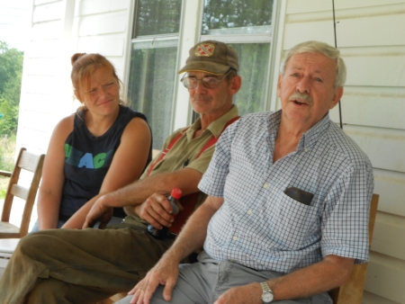 |
Pat
Howell (right) told us his story with Ed Silver (center)
listening. Pat told us that he entered the hole during the early
summer, perhaps June about 1952 or so. He wasn't very sure of the date.
He said the hole in the side of the ravine revealed a tunnel about 20'
long and about 4' high. He said the sides appeared to have been
scraped by some
sort of tool. He reported that he found a pile of mica, about
twelve "spear points", and a stone hammer head at the end of the tunnel
by the back wall. He said that there were two other people
present at the site at the time; a "mucker", who was collecting mica
and a dozier operator who was removing the material from the side of
the ravine. He did not know the identity of the two witnesses. Pat said
that he gave the mica to the "mucker" and took the arifacts home.
He said that the artifacts had been loaned to various relatives over
the years and were now lost. |
I asked Pat several questions after he told his story. Most importantly, I asked him to describe the "spear points". He said that the "spear points" were about the length of a cigar box (8"-10") and that they were tan or gray in color. We discussed the color of the "spear points' a bit because the mining tools discovered at the Sink Hole Mine in 1913 and transported back to the Smithsonian were not well shaped and were dark in color. His description of the tunnel was consistent with Kerr's description of ancient Native American mining tunnels (Kerr, W.C., "Reports of the Geologic Survey, 1875). Pat seemed to have a very clear memory of the details of the discovery.
 |
After our discussion on the porch, we all went out to the ravine at the Sink Hole Mine and Pat showed us approximately where the tunnel had been. Of course there was no longer any tunnel as a great deal of the material on the sides of the ravine was later removed during "mucking' operations. But, Jeremiah and I marked the location with a green line with an old railroad spike anchoring the line in the ravine. |
My conclusion at the end of the interview with Pat Howell was that the discovery took place but that there would probably never be any hard evidence that would verify his story. The attitude of the miners of the day was that "Indian" artifacts ("points") were no big deal and that there was no reason to report the discovery. So, ''mucking" mining operations went on as usual destroying any evidence that the tunnel existed. However, there have been other reports that the ancient mica miners at the Clarissa mine, which also had a large ravine, did use tunnels into the ravine side to attempt to find a mica vein.
 |
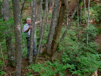
After
the completion of the interview, Pat took Jeremiah and me to his cabin
nearby the Sink Hole Mine. He lives in Spruce Pine but enjoys
using the cabin to "get away" on occasion. While at the
cabin, he talked more about carrying water from the Sink Hole Creek to
the miners at the mine. The sometimes gave him a few pennies or a
nickel for his work. Eventually he earned enough to buy the frame
of a bike which he fixed up and used for many years. As an adult,
Pat worked as a miner at a feldspar mine. Pat gave me a large piece of green muscovite mica he had in a pile outside his cabin. This is about the size of a piece of mica the Hopewell would have been interested in collecting at the Mitchell County mica mines. |
After the interview with Pat Howell and the visit to his cabin, Jeremiah and I returned to the Sink Hole Mine and walked around exploring the mine site. We also looked over the land surrounding the mine for any evidence we could see of a Native American mica workshop described by Dr. Holmes in his book. Jeremiah was also interested identifying land areas near the mine that might have hosted a Native American settlement. We identified several interesting prospects for both the mica workshop and possible settlement locations. My job during the rest of the summer was to learn more about the Robinson and Clarissa mine sites and to determine who owned several prospective sites for further exploration in the fall.
The Painting |
I realized after Jeremiah's first visit that it would be some time before we would be able arrange an actual archeological dig to attempt to discover a Hopewell presence as ancient miners. But, I was getting more excited about this project with each new step in the process. During a phone call, Peter Margolin (who wrote that great article about the Sink Hole Mine and its history), told me that his article did not get much attention in the general public. So, I decided to write an article for a major North Carolina magazine with a large general circulation, such as "Our State" or "WNC Magazine". As I'm not the typical contributor for a feature article for magazines of that caliber, I decided that I would need a real "eye catcher" to get the editor's interest. In August, I was fortunate to find a talented local artist, Jerry Newton, who was interested in doing my concept of a painting that would not only tell a story about Navive American mica mining, but also use natural materials in the process. More details about the Painting are available at the link. The painting was completed during the spring of 2013 and I will display the it at various venues during the summer and formally present it at the North Carolina Gem and Mineral Show in Spruce Pine on August 3rd, 2013. Not much has happened on writing the magazine article. So, for the time being, this website will have to do.
Exploring the Clarissa Mica Mine- November 2012
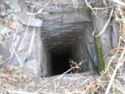
I became aware that there was a Clarissa Mica Mine in Cane Creek in 2011. I was driving on the the Cane Creek road from Bakersville enroute to the Hawk Mine when I saw Dellinger's Grist Mill on the right hand side of the road. There was a pickup truck there so I stopped by to get directions to the Hawk Mine and met Jack Dellinger. Jack is not only the fourth generation miller/millwright in his family for this historic treasure but he found time during his career to be member of the IBM team that wrote the computer code that controlled the Saturn V rocket for Apollo 11's trip to the moon. I enjoy stopping by to visit Jack every few weeks during the "season" to trade books and just enjoy some great conversation. His life growing up as the son of a miller/millwright in the !940s provides plenty of great stories and insight about mountain culture back then! One of his stories concerned a local tale about the discovery of the Clarissa Mine. He said at the time that he had relatives that lived near the mine and that he had been there as a teenager. He was confident that we could find the mine. So, on November 13th, 2012 Jack and I found and explored the Clarissa Mine. It is overgrown and access is difficult but it does have an important role to play in the study of ancient Native American mica mining in western North Carolina. Kiel and Egliff's archeological study completed on the Wilson Farm not far from the Clarissa Mine is of partucular interest.
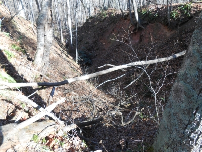 |
This is the ravine that is the site of the Native American ancient mica mining at the Clarissa Mine. It is very similar to the mineworks at The Sink Hole Mica Mine. I used William H. Holmes' topographical map from his 1919 book to help find the ravine! |
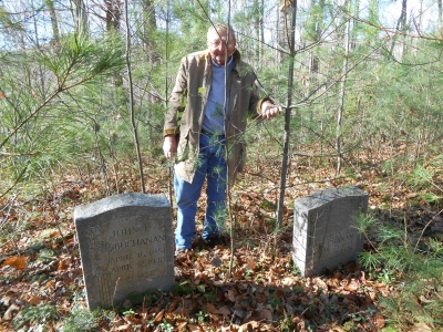 |
This is Jack Dellinger at the graves of two of his grandparents in a family cemetery located at the top of the hill not far from the location that I took the picture of the Clarissa Mine's Native American mineworks. |
Robinson Mine
I made numerous trips during the summer and fall of 2012 to the Mitchell County Mapping Office and to Bandana to talk to local residents to determine the location and land ownership of the Robinson Mine and surrounding property. I was able to determine the location of the Robinson Mine with help from Ed Silver and a couple named Carolyn and Alvin Livingston. Carolyn and Alvin live on Johnson Hollow Road at the bottom of the hill adjacent to the old Robinson Mine site. But, I learned that the mine and related mica workshop had been demolished, fill dirt brought in, and landscaped to provide land to expand the existing Silver Chapel Baptist Church cemetery. I also learned that the location of the Native American "ancient's" mica workshop at the top of the hill between the Sink Hole and Robinson mines indicated on William Holmes' topographic map had also most likely been demolished and landscaped to provide cemetery space on the Sink Hole side of the cemetery.
Allvin and Carolyn are enthusiastic supporters of our research. Alvin's grandfather was a miner. He was the younger brother of William Robinson who was the owner and operator of both the Sink Hole and Robinson mines during Wiliam H. Holmes' visit in 1913. Alvin's mother was the daughter of Edward Robinson, niece of William Robinson.
Jeremiah Stager's Second Visit - December 4-6, 2012
Jeremiah arrived with a a friend, Jesse Morton, from Mississippi State, who is also a graduate student of archeology on December 3rd, 2012. The next day, on December 4th, Alvin and Carolyn Livingston hosted a meeting at their home on Johnson Hollow Road to meet with Jeremiah and Jesse to discuss their research project. We discussed whether their corn field across the road might be a potential site for searching for evidence of an ancient Hopewell settlement in proximity to the Robinson Mine. The corn field is a popular spot for local residents who are interested in finding "points". Jeremiah and Jesse took a walk in the corn field to check it out. When they returned, several other local residents had showed up to join the party; Emily and Patrick Blueridge who are interested in the research and Helen McKinney who runs the Bandana Community Center. Helen took us on a tour of the Community Center which contains many historical photographs and documents from Bandana's mining days. Next, Emily and Patrick drove Jeremiah, Jesse, and me up the hill on Water Street to meet Roy McKinney and his wife Joan Grindstaff McKinney to see Roy's collection of "points".
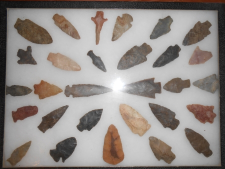 |
This is just a small portion of Roy's collection of local "points". Jeremiah and Jessy spent quite awhile studying Roy's collection. After inpecting the collection, Jeremiah said that many of the "points were spear heads from the Woodland Period. |
During the meeting with Roy and Joan, Joan mentioned that her father, Vernon Grindstaff, had found some stone mine tools at the Sink Hole Mine and had loaned them to the North Carolina Mineral Museum to display. This, of course, got our immediate interest. However, unfortunately, I have subsequently followed the trail of the stone mine tools from the Mineral Museum to the The University of North Carolina Asheville and am at a dead end at this point. There are no written records and I have yet to find anyone who knows about them. I will continue to investigate this in 2013.
The next day, I paid a visit to Carolyn and Alvin Livingston while Jeremiah and Jesse met up with Ed Silver to take at the Silver properties on Water Street. Carolyn and Alvin had a big surprise fo me. Alvin had found some stone artifacts in his basement which he thought came from his grandfather's barn.
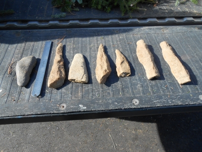 |
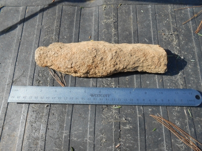
These are the stone tools that Alvin found in his basement and has loaned me to use in our research. The tool to the left of the ruler is dark in color and appears to be similar to the tools found at the Sink Hole in the early 1900s and later taken to the Smithsinian by William Holmes. The tools to the right are better shapped and consist of a light colored igneous rock that I am calling granodiorite. |
 |
The three pointed tools are similar to objects found at the Wilson Farm on Cane Creek. They are called drills. I suspect that these are similar to the "spear points" thet Pat Howell found in the Sink Hole mining tunnel in te 1950s. I plan to meet with Pat i Spruce Pine in June, 2013 and have him comment on the degree of similarity. We used this tools as a model for the mining tool being used by the Native American miner in the Painting |
 |
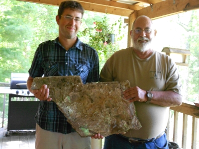
I think that the two elongated rectangular objects are chisels. I loaned one to Jeremiah t have it evuated at the Archeology Department at the University of Alabama. Jeremiah reorts that their opinion is that they have been definitely worked to achieve some function but they have no way of determining how old they are. |
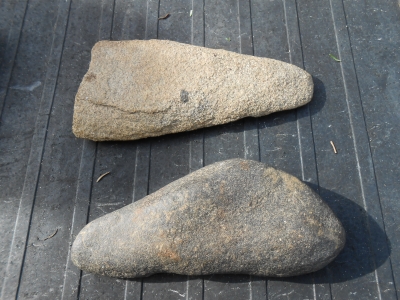 |
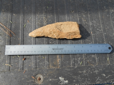
Tools similarly shaped to the tool in the top of the image were found in the Wilson Farm study on Cane Creek. I am tld they are called celts and were used in some sort of earth moving function such as digging. The tool at the bottom is similar to the mining tools discovered at thye Sink Hole Mine by kern and Holmes. |
When I caught up with Jeremiah and Jesse, I found them in a field with Ed Silver. He was showing them some of the "points" he had collected over the years.
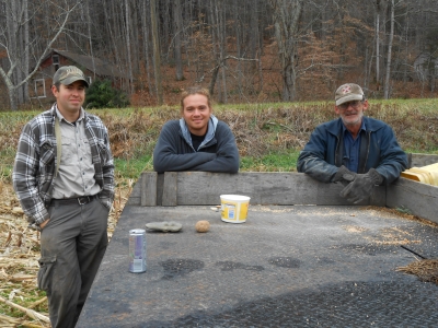 |
Jeremiah Stager (left), Jesse Morton (center), Ed Silver (right) Not only did Ed have some very interesting "points", but he gave Jeremiah and Jesse a lot of historical Information about his family and the Sink Hole Mine (A.K.A. The Silver Mine). One big bit of new information was the location of the William Robinson homestead! (see below) |
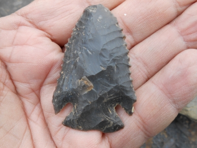 |
Jeremiah was very excited about this "point" in Ed Silver's collection. He thought it was a"Snyder Point" which would have indicated that it came from a Hopewell source. It turned out later that the "Snyder Point" was actually much older and was associated with the Early Woodland Period. |
 |
This is the well which is the only remaining structure of the William Robinson homestead! The two chimneys (one which served four fireplaces and one which served three) were removed only a few years ago to make more room for more growing space. The homestead must have been a fine structure, two floors and at least three bedrooms. This is where General Clingman stayed when he visited the Sink Hole and Robinson mines in 1868 (Holmes and Margolin). Clingman sank a shaft at the Robinson Mine in the search of gold or silver but only found mica. |
|---|---|
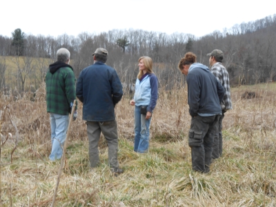 |
Left to right: Pat Blueridge, Ed Silver, Emily Blueridge, Jesse Morton, Jeremiah Stager. Jeremiah and Jesse spent some time exploring this field adjacent to the Robinsin homestead. They found some flakes of dark chert, possibly Knox chert which might indicate the presence of a Hopewell settlement. This find could lead to further exploration in the area in 2013. |
December 6th, 2012- Clarissa Mine
Jeremiah and Jesse spent the final day of their visit exploring the Clarissa Mine and evaluating the surrounding Cane Creek floodplain flatland for potential settlement site locations.
/ Home / Painting / 2012 / 2013 / Back Story and Research
If you have any suggestions or comments, please email me at bo_smith@bellsouth.net.
Website created by Robert S. "Bo" Smith